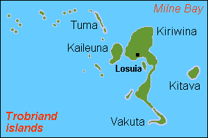
Kiriwina Island, Papua New Guinea

Cruise Port

Kiriwina Island

Island of Papua New Guinea.

View on map

Overview

Kiriwina Island is a cruise port in Papua New Guinea. It lies on the coast at approximately -8.667, 150.917.

About Kiriwina Island

Kiriwina is the largest and most populated of the Trobriand Islands, situated in the Solomon Sea, with an area of 290.5 km2 (112.2 sq mi). It is part of the Kiriwina-Goodenough District of the Milne Bay Province of Papua New Guinea. Most of the 12,000 people who live in the Trobriands live on Kiriwina. The Kilivila language, also known as Kiriwina, is spoken on the island. The main town is Losuia. The island falls under the administrative division of Kiriwina Rural LLG.

Overview text adapted from Wikipedia, available under the CC BY-SA license.

Around Kiriwina Island

Karta PG Trobriand isl
A Kiriwina Village, Memoirs Bishop Museum, Vol. II, Fig.
ChildrenKiriwina c.1980

Weather & best time to visit

Typically warmest around 29°C in Jan and coolest around 28°C in Jun (average daytime highs).

Jan
29°
27°
Feb
29°
26°
Mar
29°
27°
Apr
29°
27°
May
29°
27°
Jun
28°
26°
Jul
28°
26°
Aug
28°
26°
Sep
28°
26°
Oct
29°
27°
Nov
29°
27°
Dec
29°
27°

Average daily high / low in °C. Source: Open-Meteo.

Nearby cruise ports

Straight-line distance from Kiriwina Island.

Where to stay

Staying near Kiriwina Island the night before or after your cruise makes embarkation easier. Browse hotels near the port →

Cruise season & schedules

Which ships call at Kiriwina Island, and when, changes by season. Check the latest arrivals and departures before you plan. See current cruise schedules →